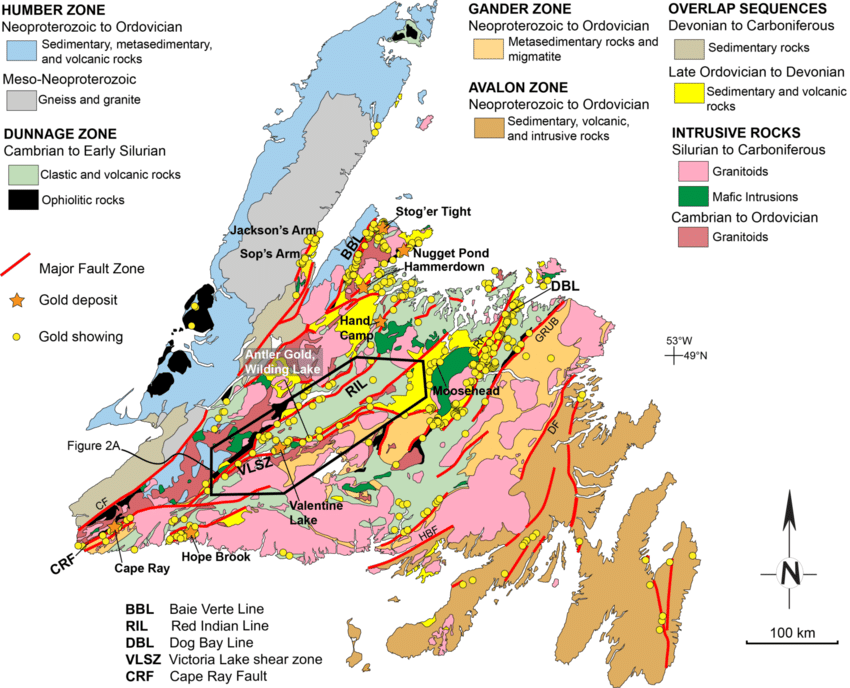
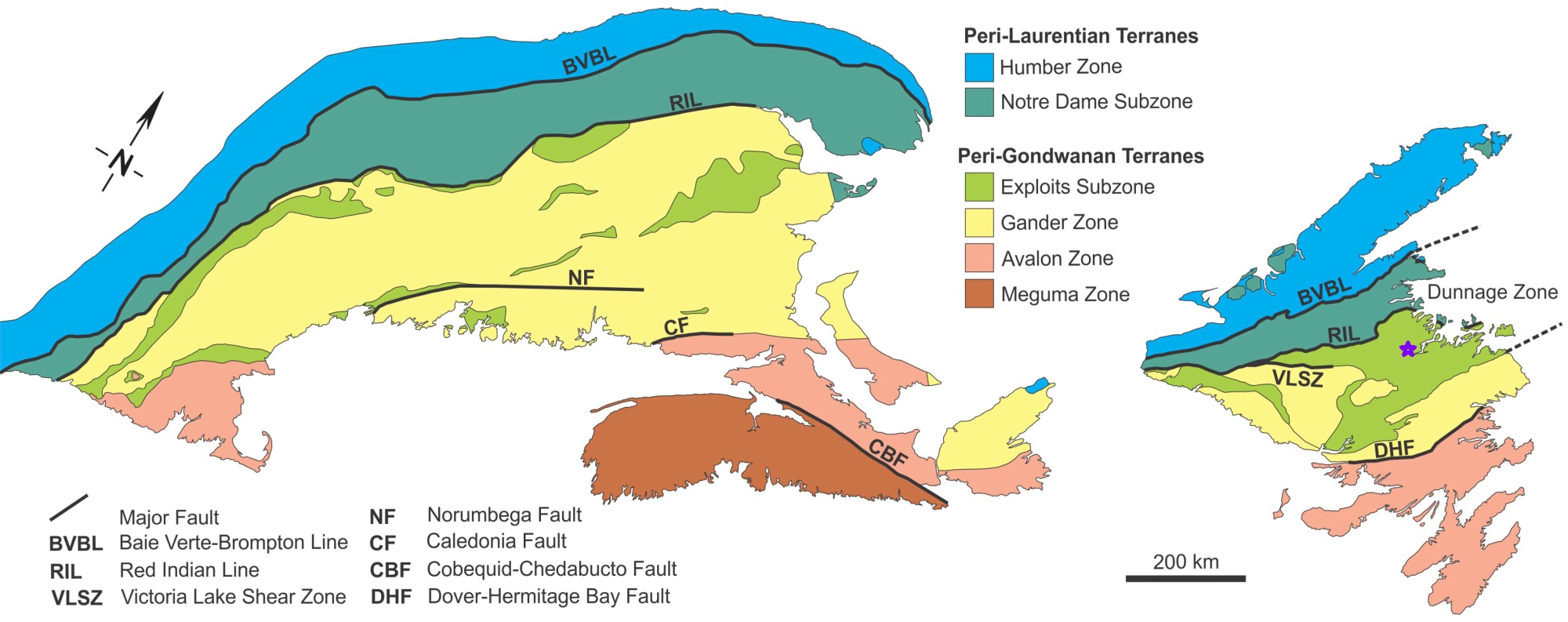
Major Faults

Through the property are two faults. Along with these faults there are other major faults in the area.

Silurian “Orogenic activity” in the Newfoundland Appalachians includes: abundant strike-slip faulting (with pull-apart basin formation); penetrative deformation; metamorphism; and plutonic and subaerial volcanic activity (Karlstrom et al., 1982; van der Pluijm, 1986; van der Pluijm et al., 1993; Kusky et al., 1987; Dunning et cd., 1990; Elliott et al., 1991). L. Further geological research conducted by the Canadian, Provincial governments and many world class geologist around the globe have conducted work on the Dunnage Zone mineral belt: Note: little to no exploration work had been conducted on the Eagle’s Vision property prior to 2014.

Other major faults in the area.

Local Faults Surrounding Eagle's Vision

Two Minor but Major in relation – faults that are of extreme importance are the two significant faulting systems that pass directly through the Eagle’s Vision 18 Claims. These two faults passing through the property appears to have cause the rough terrane with major to minor alteration of the outcrops and many significant ridges, cliffs, fissures, cracks, dykes, sills etc. indicative to resulting multiple stringer branch smaller faults

Splay Fault – subsidiary faults that branch from the main faulting system.

The “Structural Diversity” of the over-all geology, “Faulting System” of the Eagle’s Vision property itself is complex. As mentioned above, these two faults that run through the 18 claims has multiple ridges, stock-work stringers zones, significant alterations, and multiple shallow bogs below and upon top of ridges with massive irregular quartz veining/veinlets covering many outcrops and sub-crops. A prospectors and geologist haven!

Silurian Collision of Ganderia and Laurentia along the Dog Bay Line

Generalized geologic map of the northern Applachian orgen, adapted from Hibbard et al. (2006)

Published in 2018 Hornberger and Bleeker examin the Orogenic comparison of structurally controlled gold systems of the Abitibi Greenstone Belt and central Newfoundland Appalachaians: Implications for Newfoundland gold potential an recurring tectonic drivers of gold mineralization.

Faults:
BBL:   Baie Verte-Brompton line;
RIL:    Red Indian Line;
DBL:   Dog Bay Line;
GRUB: Gander River Ultramafic Belt;

Eagle’s Vision location

Other Faults:
DHF:   Dover-Hermitage Fault;
HBF:   Highland Boundary Fault;
BBF:   Bamford Brook Fault;
CBF:   Clew Bay Fault;
CCF:   Cobequid-Chedabucto Fault;
LL:      Leadhills Line;
LOF:   Liberty-Orrington Fault;
MSF:   Menai Strait Fault;
NSF:   Navan-Silyermines Fault;
WFZ:   Wicklow Fault Zone;
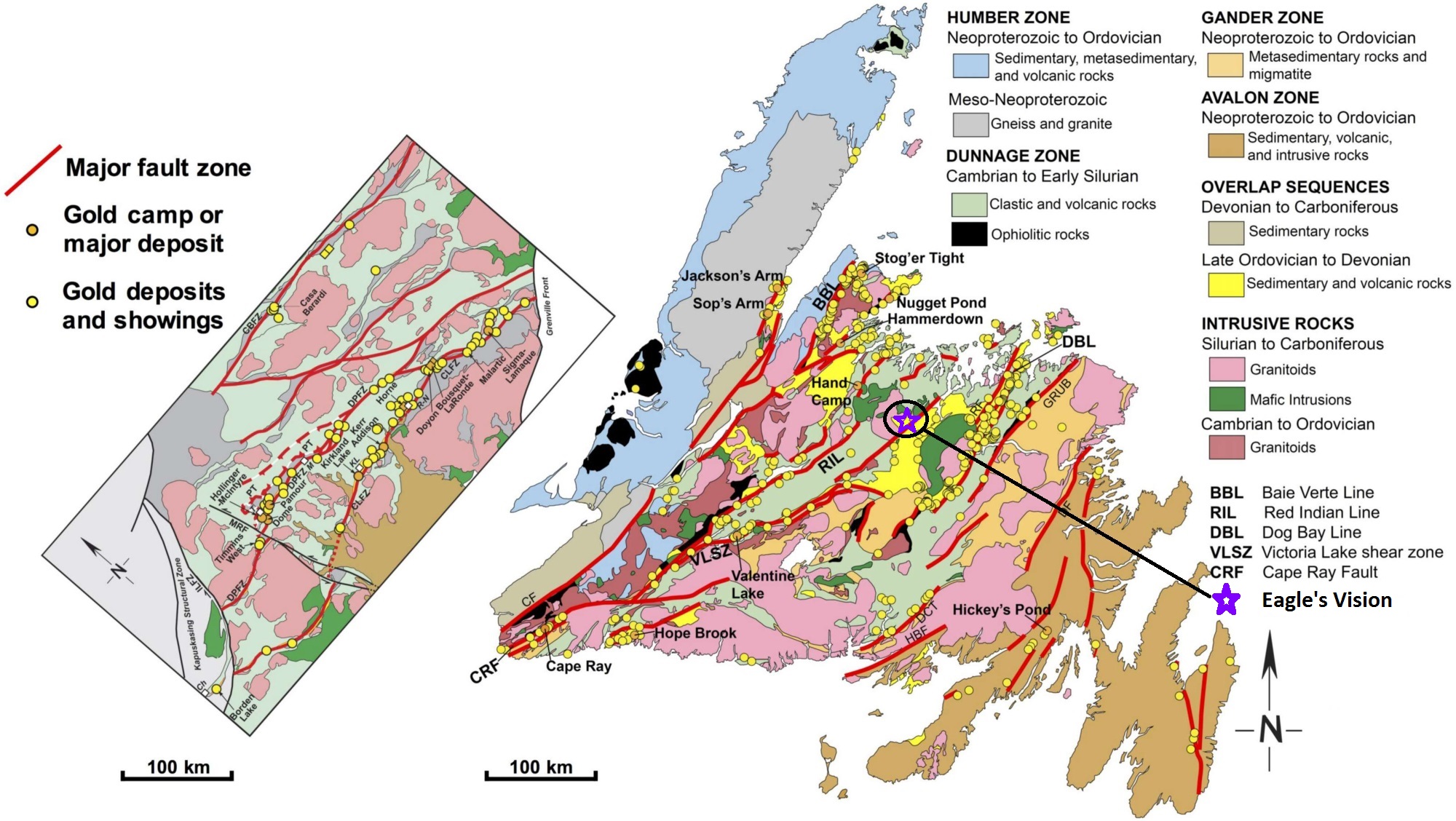
Map of northern Appalachians and Irish/British Caledonides of the restored North Atlantic region showing the position of Iapetus Ocean suture zones (after Valverde-Vaquero and others, 2006)

Newfoundland Major Faults

Comparison of Abitibi (left) and Newfoundland (Right) Structurally controlled gold systems at the same regional scale.

The map shows the importance of Major Fault Zone to the potential for Gold deposits and showing. Eagle’s Vision is located in a major fault zone. We believe this is important for our success.

Published in 2018 Hornberger and Bleeker examin the Orogenic comparison of structurally controlled gold systems of the Abitibi Greenstone Belt and central Newfoundland Appalachaians: Implications for Newfoundland gold potential an recurring tectonic drivers of gold mineralization.

DUNNAGE ZONE

Baie Verte Line; fault
Notre Dame Subzone
Red Indian Line; fault
Exploits Subzone
Dog Bay Line; fault

Eagle’s Vision location

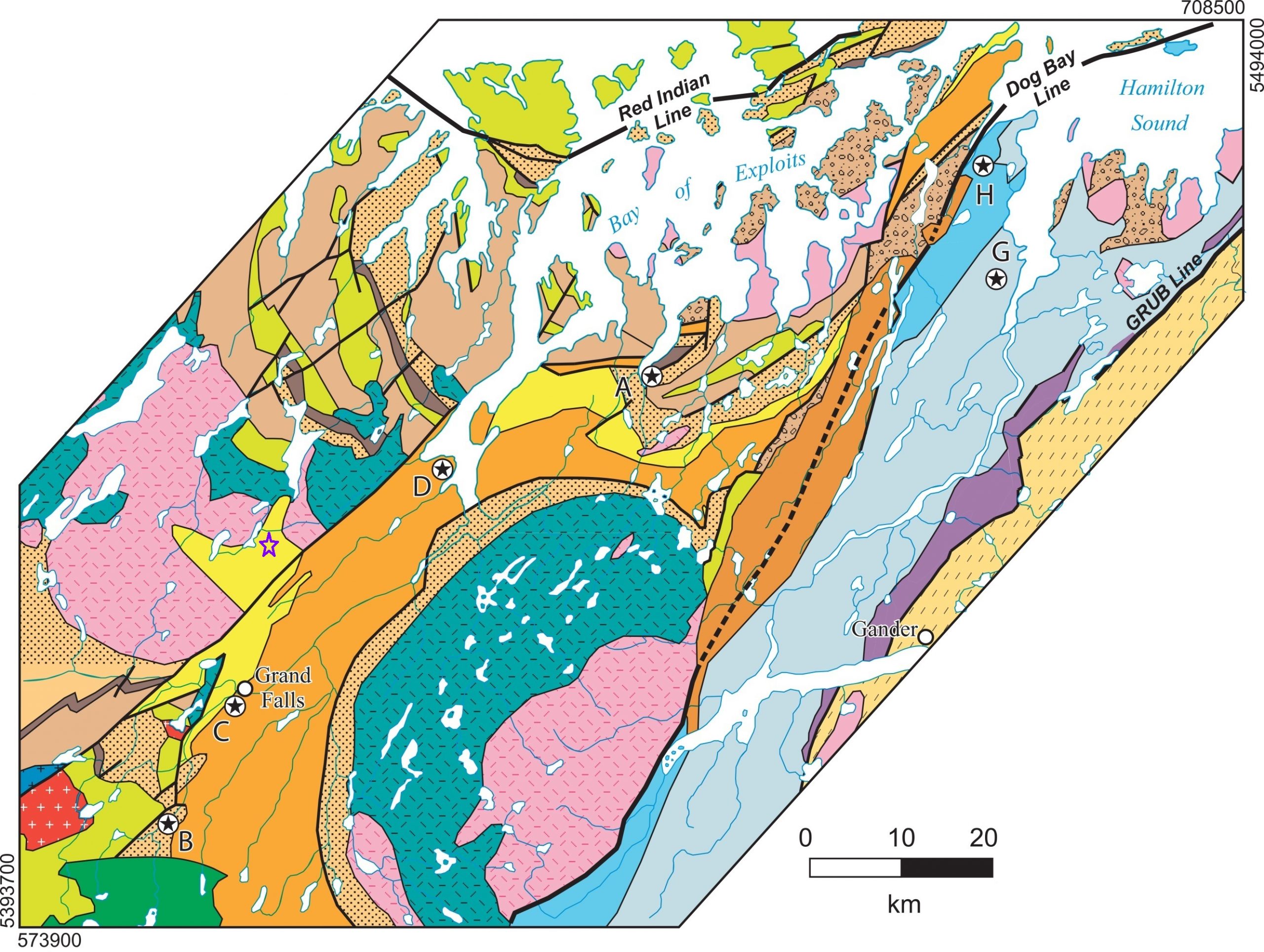
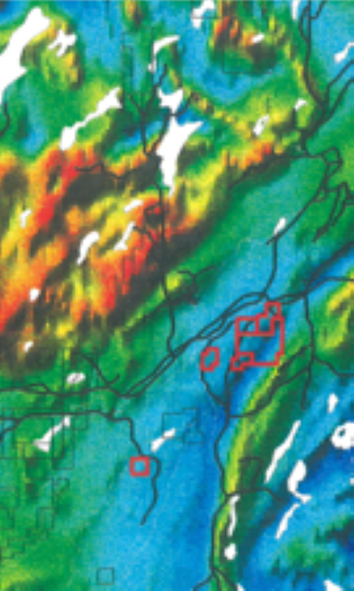
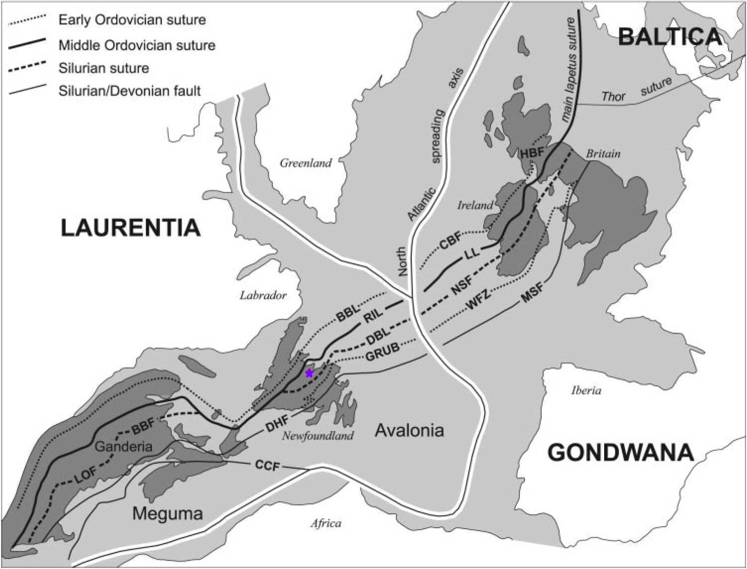
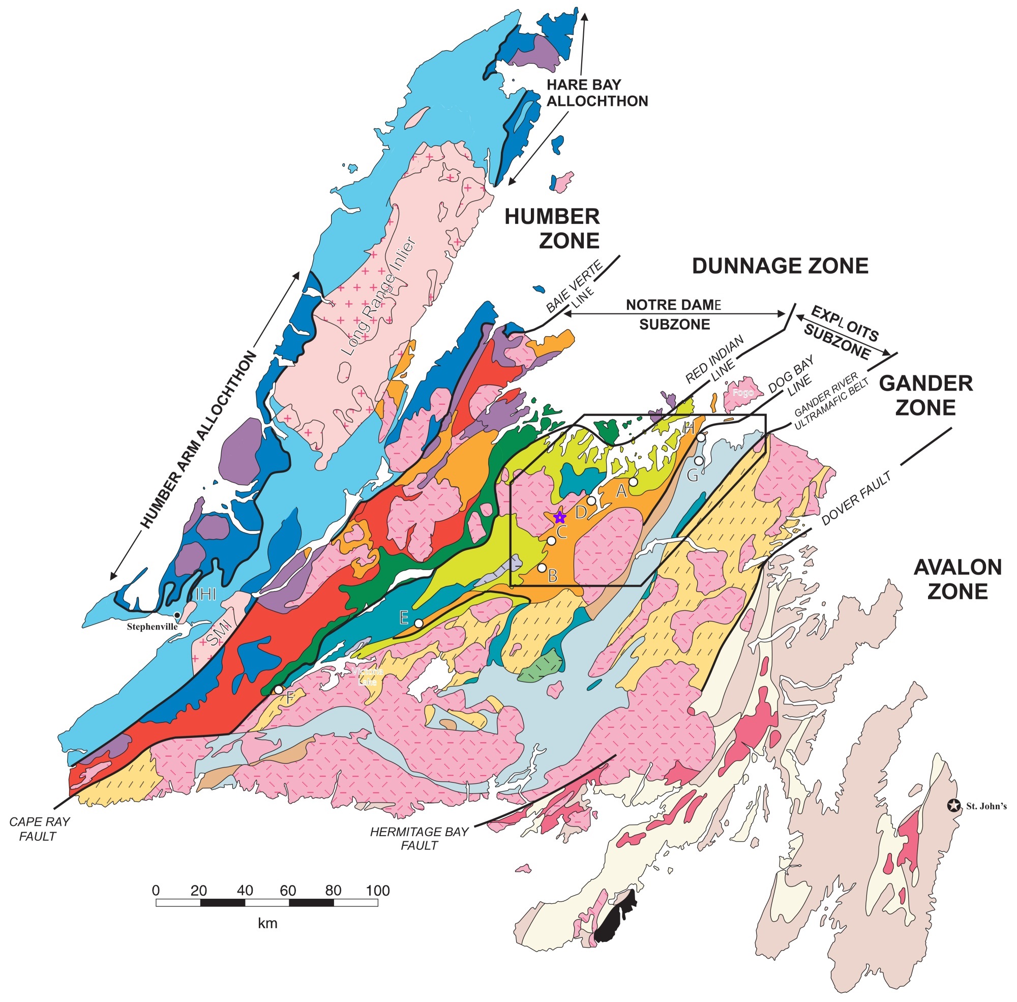
Four (4) Major Tectonic Faults (Silurian collision of Ganderia and Laurentia along the Dog Bay Line) The Eagles Vision Property (Dunnage Zone 2E/04) is located in an area where Four (4) Major Faulting Events had occurred:
1. BBL: Baie Verte-Brompton Line;
2. RIL: Red Indian Line;
3. DBL: Dog Bay Line;
4. GRUB: Gander River Ultramafic Belt
– major tectonic events.

Central Newfoundland Major Faults

DUNNAGE ZONE

Red Indian Line; fault
Exploits Subzone
Dog Bay Line; fault
GRUB: Gander River Ultramafic Belt;

Eagle’s Vision location

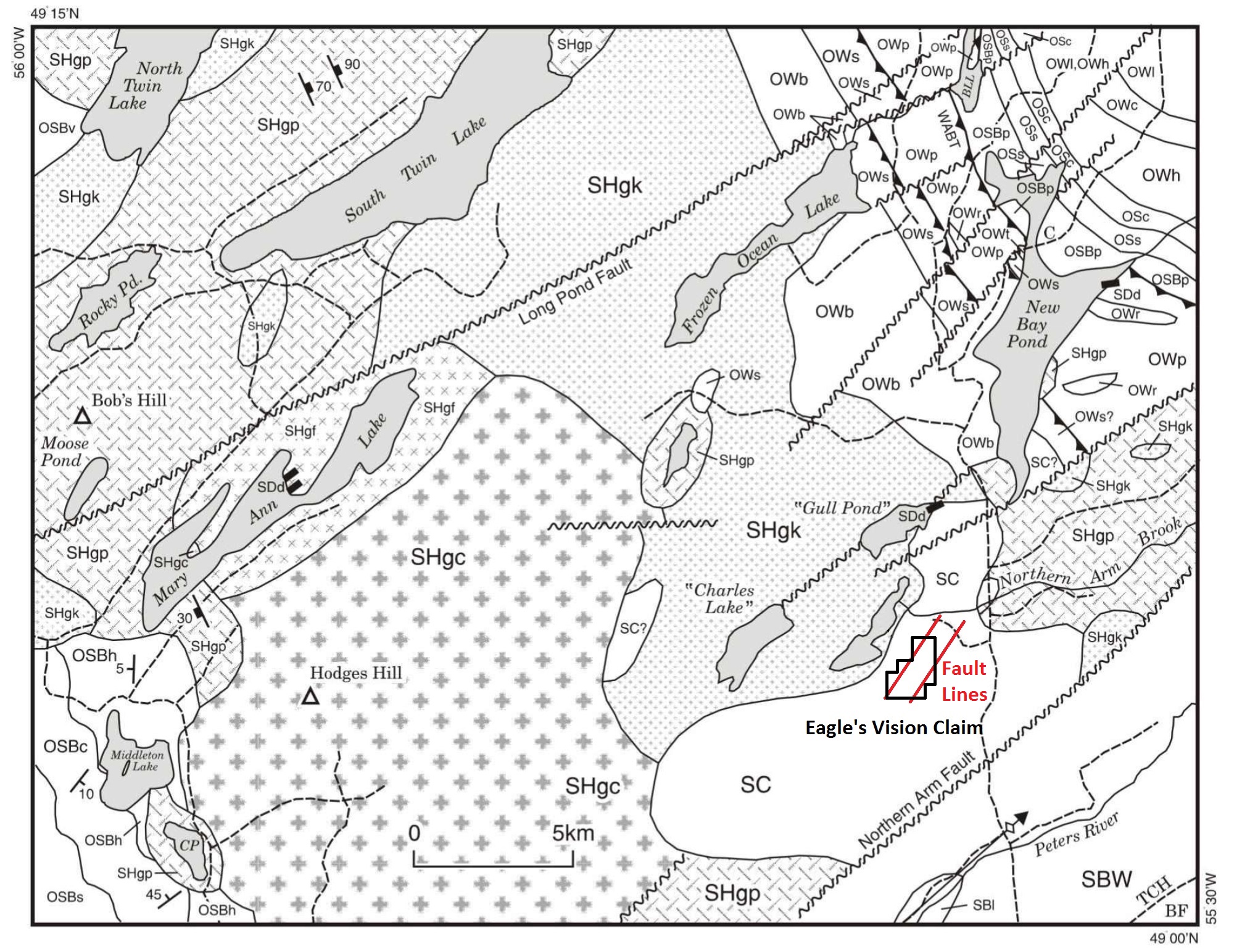
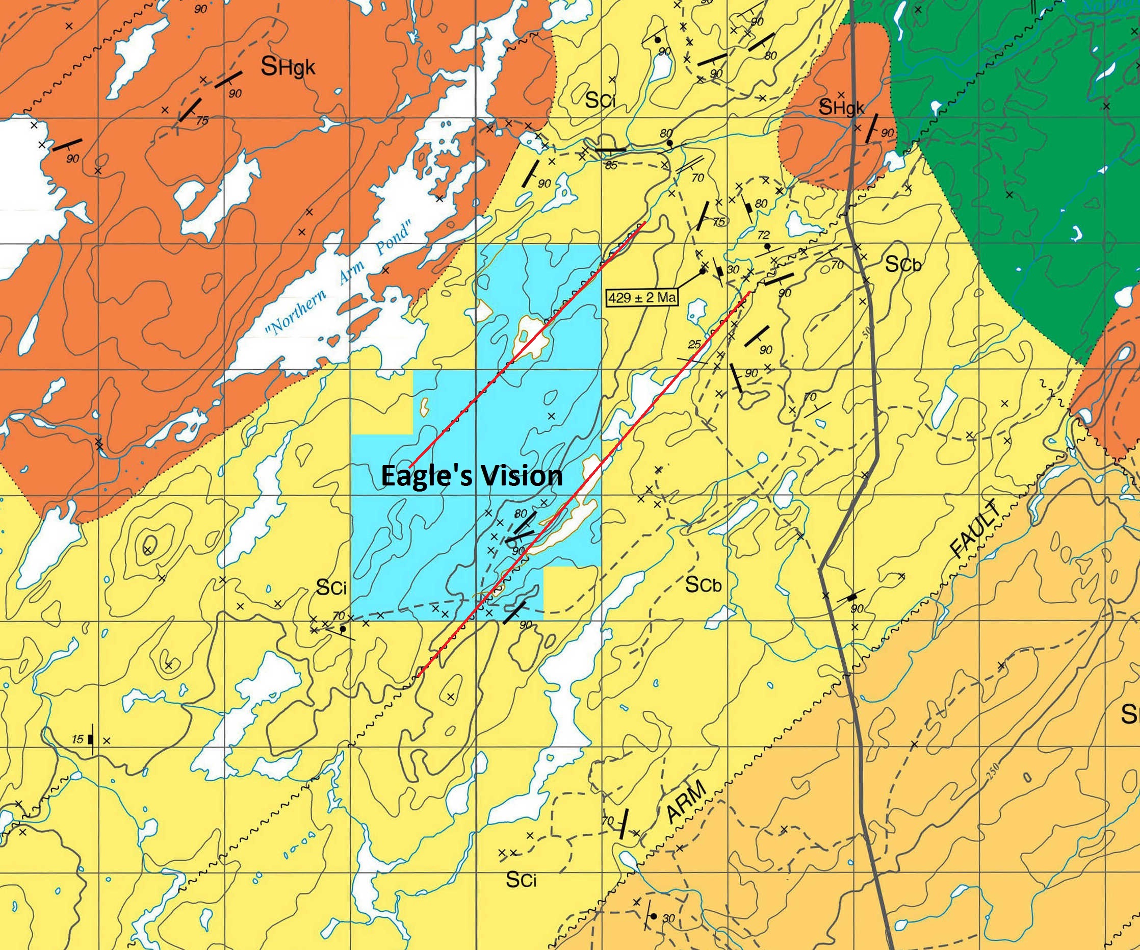
Two (2) Major / Minor Faults – The LPF: Long Pond Fault and NAF: Northern Arm Fault are in even closer proximity to the Eagle’s Vision property: part/partial in relation to 4 above faults.

The Tectonic Folding Zones are directly over our properties

Eagles Vision, William Pynns and Terry Russell Properties are all located in the Red, Yellow to Gold, and Black zones on this map indicate core multiple “MASSIVETectonic Folding of Plates that took place Multi-Millions if not Billions of years ago when the Appalachian Mountains were first formed.

Rocks in this Zone 2E/04 and proximity are aged between 1 to 2 and 1/2 Billion years old: refer to ABSTRACT, indicated in location report below:

U-Pb DETRITAL ZIRCON GEOCHRONOLOGICAL CONSTRAINTS ON
THE EARLY SILURIAN COLLISION OF GANDERIA AND LAURENTIA
ALONG THE DOG BAY LINE: THE TERMINAL IAPETAN SUTURE IN
THE NEWFOUNDLAND APPALACHIANS

  1. C. POLLOCK*, **, D. H. C. WILTON*, C. R. VAN STAAL***, and K. D. MORRISSEY* [American Journal of Science, Vol. 307, February, 2007, P. 399–433, DOI 10.2475/02.2007.04]

The Exploits Subzone Major and Minor

The Exploits Subzone is comprised of Cambrian to Ordovician Ganderian continental and oceanic arc – back-arc complexes that formed on the opposing side of the Iapetus Ocean from Dashwoods (Williams et al., 1988; van Staal et al., 1998; Zagorevski et al., 2007). Gold mineralization in central Newfoundland and mineralised rock types is concentrated along major faults within and along the Dunnage Zone – cited in maps below. The major faults include, from west to east, the Baie Verte Line (BBL) and Cape Ray fault (CRF), RIL and Victoria Lake shear zone (VLSZ), Dog Bay Line (DBL) and Gander River Ultrabasic Belt with the largest known deposits associated with the VLSZ. Present research is focused on the emerging gold district that trends northeast to north-northeast across central Newfoundland along the CRF, VLSZ, and DBL.

Note: Victoria Lake Shear Zone (VLSZ) cross-over the Eagles Vision Property and Loggers Property. Cape Ray Fault (CRF), and Victoria Lake Shear Zone (VLSZ), Dog Bay Line (DBL).

The CRF, VLSZ and DBL in central Newfoundland are thrust sutures that formed as a result of accretionary tectonics involving subduction, tectonic underplating and slab break-off (Zagorevski et al., 2007; van Staal and Barr, 2012).

The last major phase of regional deformation (DN4) is marked by Mylonite zones associated with Early Devonian thrusting that juxtaposed low- and high-grade metamorphic rocks; examples: VLSZ and CRF of such DN4 structures (Lin et al., 1994; Dubé et al., 1996; Valverde-Vaquero et al., 2006).

Zones and Faults identified through: Quebec; New Brunswick; Nova Scotia; Prince Edward Island; and on through Newfoundland.

The main gold-bearing structural belt in central Newfoundland extends northeast from Cape Ray through central Newfoundland to Northern Arm and on through ~400 km to Fogo Island.